(Full name: Willard Munger State Trail)
I (finally) finished the Munger Trail in 2024. With a close connection to Pine County, Minnesota, I have always been aware of the Munger Trail’s existence. It’s a short state trail, paved and ideal for biking, which travels through Pine, Carlton, and St. Louis Counties, or from Hinckley to Duluth. It is 70 miles long and frequently biked or walked by locals, but is rarely walked by non-locals, and it is even more rarely backpacked.

Even though I am much more interested in backpacking over hiking, this is a trail I hiked, in large part due to a dearth of public lands around the trail. But I also set the backpack aside because it’s close to home, which allowed me to hike it at less-than-optimal times and in short chunks as opportunities arose. When weather wasn’t good enough to go deeper into the woods, the Munger Trail was there as a consolation hike.
I completed the Munger’s 70 miles over the course of 10 dayhikes, ranging in length from 1 mile (the grand finale) to 14 miles (a bit too far on monotonous terrain). I split it up something like this, though there’s no real benefit to how I did it – do what works:
Section south to north – Miles (approx)
- Hinckley to Finlayson – 13.5 miles
- Finlayson to Rutledge – 6 miles
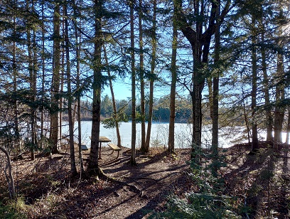
- Rutledge to Willow River – 4 miles
- Willow River to Sturgeon Lake – 5 miles
- Sturgeon Lake to Moose Lake – 6 miles
- Moose Lake to Barnum – 5.5 miles
- Barnum to Mahtowa – 6.5 miles
- Mahtowa to Carlton – 12.5 miles
- Carlton to Duluth – 14.5 miles
- Duluth finale – 1 mile
I did not hike these in order, nor did I hike them all in one direction, though I did skew northbound, as I wanted to finish with the long downhill into Duluth.
Traffic: In the ten days I spent on this trail, traffic ranged from nobody (late winter near Hinckley with ice still on parts of the trail) to absolutely everyone (the last nice autumn weekend of the year in Duluth). Your best bet is midweek, and the farther you get from a town, the more likely that you’ll only encounter a few long-distance bikers.
Challenges: The trail often follows Highway 61, so traffic noise is a frequent companion. It’s a good trail for podcasts.
Also because it’s near busier areas and often adjacent to private lands, bathroom breaks are very challenging. As the trail leads into Duluth, finding an unpopulated place to pull off becomes extremely hard, bordering on impossible.
The terrain is monotonous, so while it is extremely easy, it’s tough on the feet and joints.
The good stuff: This is not a wilderness trail and it’s not trying to be. You’ll see some good things though. My favorite spots were:
- Sand Lake just north of Hinckley. This is a historic location related to the terrible Hinckley fire. If you plan to explore this area, make a stop at the Hinckley Fire Museum near the southern terminus and learn about Sand Lake’s importance.
- Finlayson to Rutledge. This section veers off the railroad right-of-way and wiggles around a little more than other sections. It was really enjoyable.
- Otter Creek to Carlton. It had a deeper woods and access to a pretty lake.
- Everything from Carlton to Duluth. It’s much more dramatic, with more remote areas, some incredible rocks, but many more people.
Could you thru-hike this? I’ve thought about this a lot, and I would lean towards no, unless you have local support to help you get to legal camping. You would need to do some extensive research on public lands around the trail and be willing to put in some long days and/or bonus miles to get to campgrounds.
There are a smattering of trail shelters or rest areas along the way. The most appealing one is south of Rutledge, shown on the map with a picnic table. This felt far enough out of town that it would be unlikely to bother locals, but whether or not it’s legal, well, do your own research.
There are several campgrounds shown on the map, but most would be one heck of a hike to get to. The best bet would be the municipal campground in Moose Lake, which isn’t too many blocks off the Munger. South of Carlton, there was a picnic area that appeared to have been camped at, but again, the legality was not clear, and the public land is limited. Jay Cooke is worth the side trail. Warning: this is a very popular place to camp, so book well in advance. North of Jay Cooke, the Buffalo House has camping, but its proximity to Jay Cooke State Park makes it almost irrelevant.
There are several picnic icons on the map between Jay Cooke State Park and Duluth and I half-expected them to present some camping opportunities. One of them had a shelter, but was within City limits, so no dispersed camping is allowed. Another was right by a road and was not on camping-friendly terrain. Another picnic icon didn’t seem to exist in real life.
I’m not saying you couldn’t thru-hike it, but I’m not sure it’s worth the effort.
Navigation: There is one place you could get lost – in downtown Carlton where a spur trail leads in another direction. You’d figure it out. Maps are free from the Minnesota DNR. The mileage guide did not seem 100% accurate, and my GPS line differed slightly from the map at times, but all were pretty minor deviations, and there’s a decent chance I was wrong and not the map.
Bottom line: It was a nice trail to pick at during shoulder seasons. I think if I were biking, I would rate the trail much more highly, but the ratio of legitimately cool stuff to long, long miles on pavement doesn’t highly recommend it. Still, it exists, and I am glad I hiked it.
